How to Read the NYC Subway Map Like a Local (2026 Guide)
The NYC subway map can look overwhelming at first glance. With 27 lines, 472 stations, and a web of colored routes crisscrossing the city, it's easy to feel lost before you even step foot underground. But once you understand how locals read it, the map becomes your best friend for navigating New York City.
New Yorkers don't memorize every line or station. Instead, they understand the map's language: what colors mean, how directions work, and which symbols indicate transfers. This guide breaks down the NYC subway map reading process into simple, practical steps that will have you navigating like a local in no time.
Whether you're a first-time visitor planning your route to Times Square, a tourist figuring out how to get from Brooklyn to Manhattan, or a new resident learning your daily commute, this guide will transform that confusing map into a clear navigation tool.
Why the NYC Subway Map Looks Confusing
At first glance, the NYC subway map appears chaotic. Lines overlap, colors blend together, and stations seem to cluster in ways that don't match the actual geography of the city. This confusion is understandable, and there are specific reasons why the map looks this way.
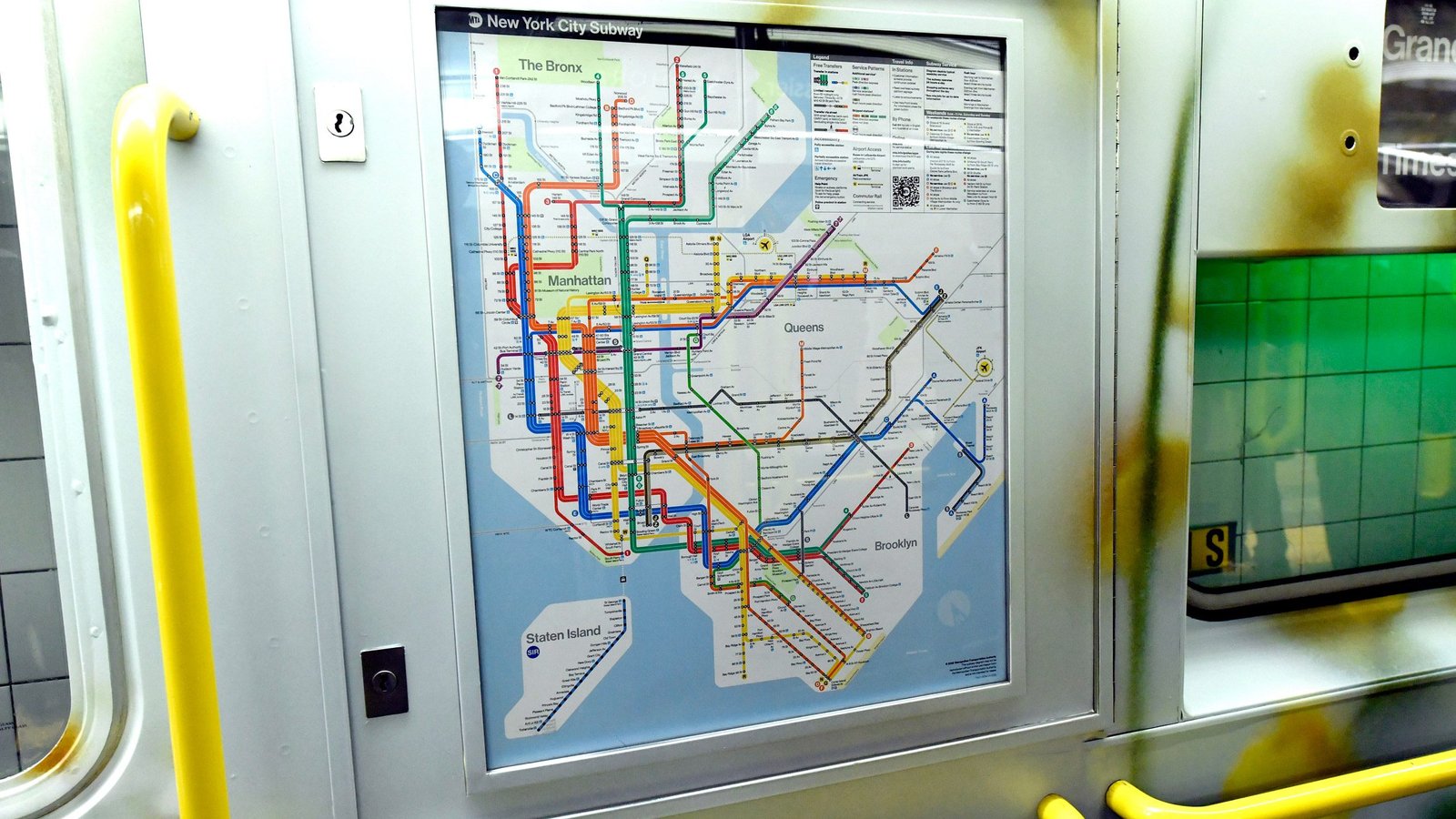
The map is a diagram, not a geographic representation. Unlike street maps that show actual distances and locations, the subway map prioritizes clarity of connections over geographic accuracy. Stations are spaced for readability, not distance. This means two stations that appear close on the map might be several blocks apart in real life.
Multiple lines share the same tracks in many areas. When you see several colored lines running parallel, they're often using the same physical tracks. The map shows each line separately for clarity, but in reality, you might be waiting for a train that serves multiple lines.
The system serves five boroughs with different layouts. Manhattan's grid system contrasts with Brooklyn's angled streets and Queens' sprawling neighborhoods. The map has to represent all of this on one page, which requires simplification and abstraction.
Service patterns change throughout the day. Express trains become local trains, some lines skip stations during rush hour, and weekend service differs from weekday service. The map shows all possibilities, which can make it look more complex than your actual trip needs to be.
Once you understand that the map is a tool for finding connections rather than a precise geographic guide, it becomes much easier to read. You're looking for routes, not exact locations.
Understanding Colors, Lines, Letters & Numbers
The NYC subway map uses a color-coding system that groups related lines together. Understanding this system is the first step to reading the map like a local.
Colors represent line families, not individual trains. For example, the red color represents the Broadway-Seventh Avenue line family, which includes the 1, 2, and 3 trains. These trains share tracks in Manhattan and serve similar areas, so they're grouped together visually.
Numbered lines (1 through 7) generally run north-south through Manhattan and the Bronx. The 1, 2, 3 trains are red and run along the west side of Manhattan. The 4, 5, 6 trains are green and run along the east side. The 7 train is purple and runs from Manhattan to Queens.
Lettered lines (A through Z, excluding some letters) typically run through Manhattan and connect to Brooklyn and Queens. The A, C, E trains are blue and run along Eighth Avenue. The B, D, F, M trains are orange and run along Sixth Avenue. The J, Z trains are brown, the L train is gray, and the N, Q, R, W trains are yellow.
Each line has a specific color that helps you track it across the map. When you're planning a route, follow the color of your line from your starting station to your destination. This visual tracking makes it easier to see where you're going and where you might need to transfer.
Don't try to memorize every color-line combination. Instead, learn the system: colors group related lines, numbers run north-south, and letters often connect to outer boroughs. When you need specific information, the map provides it clearly.
Local lines are shown with a white circle in the center of the line. Express lines have a black diamond in the center. This distinction matters because express trains skip certain stations, which affects your route planning.
Local vs Express Trains Explained
One of the most important distinctions on the NYC subway map is between local and express trains. Understanding this difference will save you time and prevent you from missing your stop.
Local trains stop at every station along their route. On the map, local service is indicated by a white circle in the center of the line. If you're taking a local train, you can get off at any station the line serves.
Express trains skip certain stations to move faster. On the map, express service is shown with a black diamond in the center of the line. Express trains only stop at major stations, which means if your destination isn't an express stop, you'll need to take a local train or transfer.
Some lines have both local and express service. The 4, 5, and 6 lines in Manhattan are a perfect example. The 4 and 5 trains run express, stopping only at major stations, while the 6 train runs local, stopping at every station. They share tracks but serve different stations.
Express service is most common during rush hours. Many express trains become local trains during off-peak hours, on weekends, and late at night. Always check service alerts or use a transit app to see current service patterns, as the map shows all possibilities, not necessarily what's running right now.
If you're unsure whether a station is express or local, look for the station name on the map. Express stations are typically larger or more prominent. When in doubt, take a local train to ensure you don't miss your stop.
Locals know that express trains are faster for longer distances but local trains are more flexible. If you're traveling just a few stops, local is often just as fast and gives you more options. For longer trips, express can save significant time.
Reading Directions: Uptown, Downtown & Boroughs
Understanding directions on the NYC subway map is crucial for choosing the right platform and train. The terminology can be confusing if you're not familiar with how New Yorkers describe directions.
Uptown means north in Manhattan. When you see "Uptown & The Bronx" on a sign or map, it means the train is heading north. In Manhattan, street numbers increase as you go uptown, so if you're at 14th Street and need to get to 42nd Street, you're going uptown.
Downtown means south in Manhattan. Signs that say "Downtown & Brooklyn" indicate the train is heading south. Street numbers decrease as you go downtown, so traveling from 42nd Street to 14th Street means going downtown.
For Brooklyn and Queens, directions get more complex. Trains heading to Brooklyn from Manhattan are often labeled as "Downtown" even though they're actually going east or southeast. Similarly, trains to Queens might be labeled "Uptown" even though they're heading east.
The map shows direction with arrows or by the way lines are oriented. Generally, lines going up the page are heading north or toward the Bronx, and lines going down are heading south or toward Brooklyn. Lines branching to the right typically go to Queens.
When planning your route, identify your destination's general direction first. Are you going to a higher-numbered street or a lower-numbered street? Are you heading to Brooklyn, Queens, or the Bronx? This initial orientation helps you choose the right direction.
At transfer stations, pay attention to which direction each line goes. You might need to go uptown on one line, transfer, then go downtown on another line. The map shows these connections clearly, but you need to track direction through your entire journey.
Locals always check the final destination shown on the front of the train, not just the line letter or number. A 2 train might go to different places depending on whether it's express or local, or whether it's running its full route. The destination sign tells you where that specific train is actually going.
Transfer Stations & Symbols Explained
Transfer stations are where you can switch from one line to another without paying again. Understanding how transfers work on the map will help you plan efficient routes across the city.
Transfer stations are marked with specific symbols on the map. Look for stations where multiple colored lines intersect or connect. These intersections indicate places where you can change trains.
Free transfers are available within two hours of your initial fare payment. You can transfer between subway lines, from subway to bus, or from bus to subway. The system tracks this automatically when you use the same payment method.
Some transfers require walking between stations. The map shows these with connecting lines or notes. For example, transferring from the 1 train at Times Square to the N, Q, R, W trains might require walking through a passageway. The map indicates these connections, but allow extra time for station transfers.
Same-platform transfers are the easiest. At some stations, you can simply walk across the platform to catch a different line. These are ideal because you don't need to navigate stairs or passageways. The map doesn't always show this detail, but transit apps usually indicate same-platform transfers.
Look for stations where your line color connects with another line color. These intersections are your transfer opportunities. When planning a route, identify where you'll need to transfer and which station offers that connection.
Some transfers are more convenient than others. Major hubs like Times Square, Union Square, and Atlantic Avenue offer multiple transfer options. If you have a choice, these major stations are usually easier to navigate than smaller transfer points.
Weekend and late-night service can affect transfers. Some lines don't run on weekends, and express trains become local, which can change your transfer options. Always check current service status when planning transfers during off-peak hours.
Weekend & Service Change Map Tips
The subway map shows all possible routes and services, but actual service changes frequently, especially on weekends. Learning how to account for these changes will prevent confusion and delays.
Many express trains run local on weekends. The map shows both express and local service, but on weekends, that express train might actually be stopping at every station. This affects your travel time and which stations you can access.
Some lines don't run on weekends at all. The W train, for example, typically doesn't run on weekends. The map still shows it because it runs on weekdays, but you'll need an alternative route for weekend travel.
Service changes are posted in stations and online. Before relying on the map alone, check for service change notices. These are usually posted on yellow or orange paper near station entrances and on platforms. The MTA website and apps also provide current service information.
Use the map as a starting point, then verify with real-time information. Navigation apps like Google Maps, Apple Maps, and the official MTA app incorporate current service changes into their directions. They'll route you around closures and account for weekend service patterns.
Plan alternative routes when service is disrupted. The map shows multiple ways to get between most points. If your usual route is affected by service changes, the map helps you identify backup options.
Major construction projects can close stations or lines for extended periods. The map shows the normal service pattern, but long-term projects might require using buses or different subway lines. Check for planned service changes if you're traveling during known construction periods.
Locals always check service status before important trips. A quick look at service alerts can save you from arriving at a closed station or waiting for a train that isn't running. The map is your guide, but current information is your reality.
Common Mistakes Beginners Make
When learning to read the NYC subway map, certain mistakes are common. Being aware of these pitfalls will help you avoid them and navigate more confidently.
Assuming the map shows geographic distance is a frequent error. Two stations that appear close on the map might be several blocks apart when you exit. The map prioritizes route clarity over geographic accuracy, so don't use it to estimate walking distances between stations.
Not checking if a station is express or local can lead to missing your stop. If you need a local-only station but board an express train, you'll pass right by your destination. Always verify whether your station is served by express or local trains.
Ignoring direction signs in stations is another common mistake. The map shows routes, but station signs tell you which platform to use. Look for "Uptown" or "Downtown" signs, or signs indicating your destination borough, to find the correct platform.
Relying solely on the map without checking service changes causes problems. The map shows all possibilities, but current service might be different. Always verify with apps or station notices, especially on weekends or during known construction.
Trying to memorize the entire map is unnecessary and overwhelming. Locals don't memorize every line and station. Instead, they learn the system's logic and look up specific routes when needed. Focus on understanding how to read the map, not memorizing it.
Not understanding transfer limitations can waste time. Some transfers require exiting and re-entering, which means you might need to pay again if it's been more than two hours. The map shows connections, but not always the transfer type or time limits.
Assuming all lines run 24/7 is incorrect. While the subway system operates 24 hours, individual lines might have different schedules. Some lines don't run late at night or have reduced service. The map doesn't show operating hours, so check schedules for late-night travel.
Pro Tips Locals Actually Use
New Yorkers have developed practical strategies for using the subway map effectively. These tips go beyond basic reading and help you navigate like someone who rides daily.
Start with your destination and work backward. Instead of starting from where you are, identify your destination on the map first. Then trace backward to find the best route. This approach often reveals simpler paths than starting from your origin.
Look for the fewest transfers possible. Each transfer adds time and potential for confusion. The map makes it easy to see direct routes versus routes requiring transfers. When possible, choose routes with fewer transfers, even if they take slightly longer.
Use major hubs as anchors. Stations like Times Square, Grand Central, Union Square, and Atlantic Avenue are major transfer points. If you're going somewhere unfamiliar, route through one of these hubs. They're well-signed, busy, and offer multiple options if you need to adjust your route.
Pay attention to line colors for quick orientation. When you're in a station, the colored tiles and signs match the map's color coding. If you see green tiles, you're on the 4, 5, or 6 line. This color matching helps you confirm you're in the right place.
Notice which boroughs lines serve for long trips. If you're going from Manhattan to deep Brooklyn or Queens, some lines go much further than others. The map shows where lines terminate, which helps you choose lines that actually reach your destination.
Use the map to identify express vs local before you enter the station. Knowing whether you need express or local service helps you choose the right platform immediately, rather than figuring it out once you're underground with limited cell service.
Look for parallel lines as backup options. If the 1, 2, or 3 trains are delayed, you might be able to use the A, C, or E trains if they serve a nearby area. The map shows these parallel routes, giving you alternatives when service is disrupted.
Memorize your regular routes, but use the map for new destinations. Daily commuters know their usual routes by heart, but they still reference the map for trips to unfamiliar areas. There's no need to memorize everything; the map is there to use.
Check the map before important trips, even if you think you know the route. Service changes, construction, and your own memory can lead you astray. A quick map check confirms your route and might reveal a better option you hadn't considered.
Frequently Asked Questions
How do I know which direction to go on the subway?
Determine if you're going to a higher-numbered street (uptown/north) or lower-numbered street (downtown/south) in Manhattan. For Brooklyn and Queens, check the train's final destination shown on the front of the train. Station signs indicate "Uptown & The Bronx" or "Downtown & Brooklyn" to help you choose the right platform.
What's the difference between local and express on the map?
Local trains stop at every station and are shown with a white circle on the map. Express trains skip certain stations and are shown with a black diamond. Express trains are faster for longer distances but only stop at major stations. Always check if your destination is an express stop before boarding an express train.
How do I find transfer stations on the map?
Look for stations where multiple colored lines intersect or connect. These intersections indicate transfer points where you can switch trains without paying again. Major transfer hubs like Times Square and Union Square are easy to spot because many lines converge there.
Does the map show actual distances between stations?
No, the subway map is a diagram that prioritizes clarity over geographic accuracy. Stations are spaced for readability, not distance. Two stations that appear close on the map might be several blocks apart in real life. Use the map for routing, not for estimating walking distances.
Why do some lines have the same color on the map?
Lines with the same color belong to the same line family and often share tracks or serve similar areas. For example, the red 1, 2, and 3 trains all run along the Broadway-Seventh Avenue corridor in Manhattan. The color coding groups related lines together to make the map easier to read.
Conclusion
Reading the NYC subway map becomes intuitive once you understand its language. The colors, symbols, and layout that seem confusing at first are actually a well-designed system for showing connections and routes across a complex transit network.
Remember that the map is a tool, not a test. You don't need to memorize it completely. Instead, learn to read it efficiently: understand what colors mean, how directions work, and where transfers are available. With this knowledge, you can navigate anywhere in the city.
Practice makes perfect. The more you use the map, the more natural reading it becomes. Start with simple routes between familiar places, then gradually tackle more complex journeys. Each trip teaches you something new about how the system connects.
Combine the map with real-time information. Use navigation apps that incorporate current service changes, check station notices for disruptions, and verify express vs local service before you travel. The map shows possibilities; apps and alerts show current reality.
For detailed station information and line connections, explore our interactive subway map. To find specific stations and their amenities, check our stations directory. And for real-time arrival estimates to help plan your trips, use our train timings page.