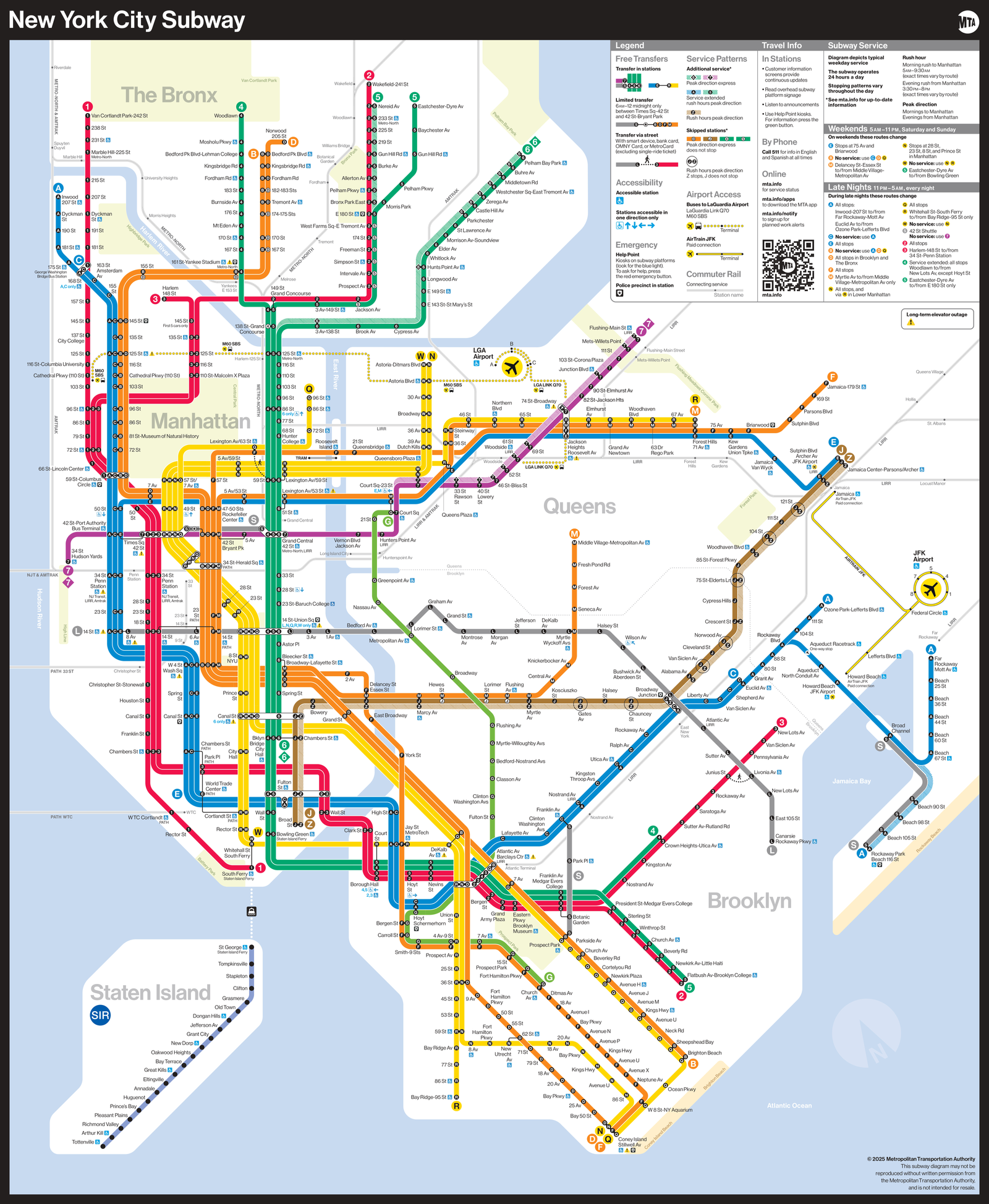
NYC Subway Map: Interactive New York Subway Guide
Explore the complete NYC Subway Map featuring all 27 MTA subway lines and 472+ stations across Manhattan, Brooklyn, Queens, the Bronx, and Staten Island. Our interactive New York subway map helps you plan routes, find transfer points, locate express and local trains, and navigate the entire NYC subway system. Whether you're commuting from Midtown Manhattan to Brooklyn or traveling from Queens to the Bronx, use our detailed NYC subway map to plan your journey efficiently.
Explore the extensive network of New York City's subway system with our comprehensive interactive map. This detailed transit map provides an overview of all 27 MTA subway lines, 472+ stations, and routes across Manhattan, Brooklyn, Queens, Bronx, and Staten Island. Plan your journey through the five boroughs with real-time route information, transfer points, and station locations. Whether you're traveling to Times Square, Grand Central, JFK Airport, or any neighborhood in NYC, our subway map helps you navigate the city's public transportation system efficiently.
NYC Subway Line Legend
The New York City Subway system operates 27 service lines across five boroughs. Each line is identified by a unique color and letter or number designation.
Red Lines (Broadway-Seventh Avenue)
Green Lines (Lexington Avenue)
Blue Lines (Eighth Avenue)
Orange Lines (Sixth Avenue)
Yellow Lines (Broadway)
Other Lines
Transfer Stations: Intersecting lines on the map indicate transfer points where you can switch between subway lines. Major transfer hubs include Times Square-42nd Street, Grand Central-42nd Street, and Atlantic Avenue-Barclays Center.
Service Types: Express trains skip certain stations for faster service, while Local trains stop at all stations. Some lines operate express during rush hours and local at other times.
💡 Tip: Use mouse wheel to zoom, click and drag to pan, or use the zoom controls above. Click fullscreen for a better view.
📞 Get Travel Information
- In Stations: Customer information displays, service update boards, digital screens, and live station agent assistance
- By Phone: Call 511 for MTA customer service and transit information
- Online: Visit mta.info for real-time service updates, schedules, and trip planning
🚇 Subway Service Details
- Operation: The subway operates 24 hours a day, 7 days a week
- Weekends: Some lines may have service changes or reduced frequency
- Late Nights: Certain express lines may run local during late night hours (typically 12 AM - 5 AM)
- Rush Hour: Express service available on select lines during weekday peak hours (typically 6:30 AM - 9:30 AM and 4:00 PM - 7:00 PM)
♿ Accessibility & Transfers
- Accessible Stations: Many stations are wheelchair accessible. Look for the wheelchair symbol on the map
- Free Transfers: Unlimited free transfers available between subway lines at designated transfer stations
- Bus Transfers: Free transfers available between subway and local buses within 2 hours using OMNY or MetroCard
- Transfer Stations: Major hubs include Times Square-42nd Street, Grand Central-42nd Street, Atlantic Avenue-Barclays Center, and Union Square
✈️ Airport & Commuter Connections
- JFK Airport: Take the A train to Howard Beach or Lefferts Boulevard, then connect to AirTrain JFK
- LaGuardia Airport: Take the 7 train to 74th Street-Roosevelt Avenue, then connect to Q70 bus to LaGuardia
- LIRR: Long Island Rail Road connections available at Penn Station, Atlantic Terminal, and Jamaica Station
- Metro-North: Connections available at Grand Central-42nd Street and Harlem-125th Street
- Staten Island Ferry: Accessible via the 1 train to South Ferry or R/W trains to Whitehall Street
Last Updated: November 7, 2025.
This map depicts typical weekly service patterns. Information is for guidance only – always check MTA service announcements for real-time service changes, delays, and planned work before your trip.
Frequently Asked Questions About NYC Subway Map
How do I read the NYC subway map?
The NYC subway map uses colors and letters/numbers to identify lines. Each line has a unique color (e.g., Red for 1/2/3, Green for 4/5/6, Blue for A/C/E). Stations are marked with dots, and transfer points show multiple lines. Express stations have white circles, local stations have black circles. Our interactive map allows you to zoom and explore all 27 lines across Manhattan, Brooklyn, Queens, the Bronx, and Staten Island.
How many subway lines are in NYC?
The NYC subway system has 27 service lines: numbered lines (1, 2, 3, 4, 5, 6, 7) and lettered lines (A, B, C, D, E, F, G, J, L, M, N, Q, R, S, W, Z). These lines operate across 472+ stations in Manhattan, Brooklyn, Queens, the Bronx, and Staten Island, covering over 665 miles of track.
What's the difference between express and local trains on the NYC subway map?
Express trains skip some stations and run faster, while local trains stop at every station. On the NYC subway map, express stations are marked with white circles and local stations with black circles. Express service is typically available during weekday rush hours on major lines like the 1, 2, 3, 4, 5, 6, A, D, and E lines in Manhattan and parts of Brooklyn and the Bronx.
How do I find transfer points on the NYC subway map?
Transfer points on the NYC subway map are stations where multiple lines intersect. These are marked with multiple colored lines crossing at the same station. Major transfer hubs include Times Square-42nd Street (connects 1, 2, 3, 7, N, Q, R, W, S), Union Square (connects 4, 5, 6, L, N, Q, R, W), and Atlantic Avenue-Barclays Center in Brooklyn (connects 2, 3, 4, 5, B, D, N, Q, R).